Monday, January 27, 2014

Group Blog #2 - Group A

Distinguish between two chosen hazards in terms of their spatial extent, predictability, frequency, magnitude, duration, speed of onset and effects. [10 marks]

In a world constantly changing, natural hazards are common and sometimes inevitable. There are numerous kinds of hazards. Namely, earthquakes, volcanic eruptions, tsunamis, hurricanes, typhoons, and drought. The chief focus of this essay is to distinguish between earthquakes and typhoons/hurricanes. 

Spatial Extent:
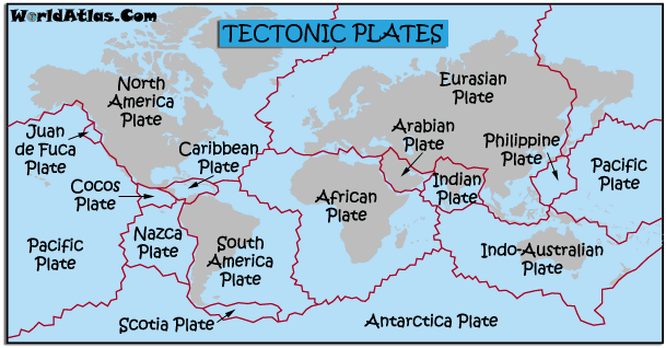
Earthquakes and typhoons are very different in that they are two kinds of extremes. Earthquakes occur within the earth, whilst typhoons are occur in the sky. Earthquakes are caused by the movement of tectonic plates, therefore they happen mostly along tectonic plate boundaries. 

Figure 1: map of tectonic plates

Figure 1 above shows the tectonic plates. A recurring location for earthquakes is Japan, which lies directly on the boundary between the Eurasian Plate and the Philippine Plate.
Typhoons on the other hand, these occur in low pressure systems above tropical waters. Eastern and Southeast Asian countries, such as Philippines, India, and China experience numerous typhoons annually. 
Figure 2: spatial distribution of hurricanes/typhoons
As evident in figure 2, typhoons are abundant along the tropics, as well as in northern Australia.

Predictability
Earthquakes and Typhoons are distinct in that earthquakes are difficult to predict, because the only definite way of predicting a quake is moments before it strikes, through foreshocks. On the other hand, typhoons can be more easily tracked and predicted. This is because typhoons form a large mass of wind, rain, and clouds that can easily be seen by a satellite.

Frequency & Magnitude
Earthquakes happen frequently, but the magnitude differs. Generally speaking, the greater the magnitude, the less frequent the quake. A magnitude of less than 2 on the Richter scale happen several million times in one year, while a magnitude of 9 or greater will occur once in 10-50 years. For example, during the 2010 Christchurch earthquake, there were 12,911 quakes within 24 hours. 
Typhoons as a whole do not occur as often as earthquakes, stronger typhoons are much more common than stronger earthquakes. Most typhoons typically occur in the months of June and July, and become less frequent in the months of January and February. The reason for the large occurrence in June/July is because of the warmer waters. Stats show that between 1959 and 2011, there was an average of 5.6 typhoons in the month of August.

Figure 3:Satellite image of typhoon Yolanda approaching the Philippines


Speed of Onset
An earthquake typically lasts only a few seconds, however, the aftershocks can continue for months after the initial quake. For example, in Japan, the earthquake that happened in April of 2011, had aftershocks as far as December 2012. Typhoons, typically last longer than an earthquake. They can last from a few hours and a couple of days, depending on the speed and velocity. 

Effects 
Both earthquakes and typhoons can potentially cause a range of damages, from minimal damage to catastrophic. 
This can be seen through earthquakes. There are thousands of quakes a day and very little are felt on the surface. Conversely, earthquakes have the potential to cause massive destruction. An example is the 9.0 magnitude earthquake in Japan. It caused a tsunami with 13,355 fatalities. 

Figure 4: Damage caused by Christchurch earthquake

Typhoons bring a lot of rain and wind to a particular area. Hurricane Frances in 2004 only caused 6 casualties, wherein Typhoon Yolanda in 2013, which was recorded as the strongest typhoon to ever hit landfall, caused 5,260 casualties. Asides from lives being taken, the livelihood of people can be destroyed. In areas such as the Philippines, during the strongest typhoons, farmers lose their crops and fishermen suffer from a decline in fish yields. The extent of these damages can be seen globally, and do not only occur in LEDC's.

Figure 5: Damage caused by typhoon Yolanda


In conclusion, earthquakes and typhoons differ greatly in characteristics, predictability, and spatial distribution, however, they are similar in that they can cause catastrophic damages to the infrastructure of an area as well as destroying the livelihoods of numerous people, especially in LEDC's. Natural hazards are, as they are called, natural. These are often inevitable and the best way to approach these hazards is to be prepared. 

Thursday, January 16, 2014

Group Blog #1 - Group A


Explain the characteristics and spatial distribution of the following hazards using at least two specific examples.

       Natural hazards are a natural threat that has the potential to cause loss of life, injury, property damage, socio-economic disruption or environmental degradation. Some examples of natural hazards include earthquakes, volcanic eruptions, tsunamis, hurricanes, typhoons, and drought. Some natural hazards could be made worse due to human activites. For an earthquake human activities such as coal mining, drilling for oil, or nuclear testing can cause earthquakes. An earthquake is a sudden, violent shaking of the earth's surface. It lasts for seconds but can cause major destruction especially in heavily populated areas. Powerful aftershocks could also be felt for a long time after the main earthquake has occurred. 


     There are different kinds of earthquakes, although all earthquakes involve the shaking of the earth due to tectonic plate movement. There are generally two kinds of natural earthquakes; the first are deep focused earthquakes which involves an oceanic plate being forced under a continental plate. The second being shallow focused earthquakes, along constructive and conservative tectonic plate boundaries. The difference between the two, being the depth where the earthquake is taking place. Deep focused earthquakes take place deep underground while shallow focus earthquakes take place relatively close to ground level. There are also intraplate earthquakes that take place within a tectonic plate rather than the boundary of tectonic plates. This occurs due to the compression of rocks. These are the type of earthquakes found in Tazmania and Australia.  There are also volcanic earthquakes where magma fractures rock and squeezes through the cracks, thus causing an earthquake. 

    Earthquakes tend to occur in the same place. This is because they occur along plate boundaries. Generally, a large amount of earthquakes occur in destructive plate boundaries, subduction zones, and collusion boundaries. For example, the Himalayas mountains are the result of collision boundaries. There are a large amount of earthquakes over a large area along the Indian and Eurasian plate boundary. Aside from the Himalayas, earthquakes occur around the edge of the pacific ocean, down the center of the atlantic ocean, around the Caribbean archipelago, the Philippine and Indonesian archipelago, east Africa, south Asia, and southern Europe. On the other hand, conservative plate boundaries such as the California San Andreas fault line, and constructive plate boundaries produce a small area of earthquake occurrences. 

Note how the earthquakes occur at tectonic plate boundaries

   As stated before, earthquakes last for seconds, however aftershocks may occur after the main quake. Aftershocks can last up to days after the main quake. For example, the Tohoku earthquake that occurred in Japan in April 2011 had aftershocks until as far as December 7, 2012. The magnitude of the main earthquake was measured 9.0 using a richter scale, which is the standard measurement of the strength of an earthquake. This earthquake and the consequent tsunami has 13,135 fatalities. 


   As stated before, earthquakes last for seconds, however aftershocks may occur after the main quake. Aftershocks can last up to days after the main quake. For example, the Tohoku earthquake that occurred in Japan in April 2011 had aftershocks until as far as December 7, 2012. The magnitude of the main earthquake was measured 9.0 using a richter scale, which is the standard measurement of the strength of an earthquake. This earthquake and the consequent tsunami has 13,135 fatalities. 


   Another example of a major earthquake is in the Philippines, a magnitude of 6.9 earthquake hit Negros, the rest of central Visayas, and some parts of Mindanao on February 6, 2012. It was at a depth of 20km. The death toll was 51, 62 missing, and 112 injured. 15,483 houses were damaged. Total cost of repair equaled 383 million pesos. 

   In conclusion, the sudden unpredictable nature of earthquakes can cause major damage in heavily populated areas such as what occurred in Japan and in the Philippines, but in general the majority of earthquakes are harmless and occur any tectonic plate boundary. 


   Earthquakes are measured using a seismometer, which gives the strength of the earthquake using the richter magnitude scale. The magnitude scale is from 1 to 10. A strong earthquake that would cause major damage would be a magnitude of 6 on a richer scale. Earthquakes are not easily predictable because the only signs of a large, impending earthquake are foreshocks (pre-earthquakes) which can easily be mistaken as small, negligible earthquakes that happen very often. The magnitude of an earthquake is proportional to the frequency of occurrence. Generally, the higher the magnitude, the less the occurrence. For example, magnitude of less than 2 on the richter scale, happen several million times in one year, while 9 or greater will occur once in 10 to 50 years. All main earthquakes are predicted seconds before it happens and lasts for tens of seconds. 


Monday, January 13, 2014

Mt. Pinatubo

Methods Used to Make Estimates of the Probability of Mt. Pinatubo

Volcanologists predict if an eruption is going to occur and when! 


General Info about Mt. Pinatubo:

  • Spring 1991 - Mt. Pinatubo in the Philippines
  • 400 earthquakes under Pinatubo
  • Magma rising from the earth's crust, mountain letting off excess steam, earthquakes from tectonic plates.
  • Mountain has only erupted 4 or 5 times in the last 2000 years. 
  • There are 4 levels of alert to warn the people.
  • June 12 was the first big blast. Explosion that sends ash 1000 ft. into the air. Eruption is 10 miles wide. 

Methods volcanologists used to estimate the probability of Mt. Pinatubo:
  • A correlation spectrometer measures sulfur coming from out of the mountain. If magma is rising, sulfur and other gases should be escaping into the atmosphere. Increasing amounts of sulfur in Mt. Pinatubo
  • Seismometer is an instrument which measures the earthquakes that occurs around the location.
  • Bird's eye view to see if the volcano changed
  • Amount of steam 
  • Historical records such as the shape of the land, eroded canyons, carbon dated trees